The geometric primitives in this one are the circle (or hexagon, as a rough approximation of a circle) and the trapezoid, which you can see surrounding the skylight as well as intersecting with the major circular structures.
I haven’t bothered to lay out the grounds on this one, though I envision twin patios in back. Nor have I added a garage / car port so far…
Having done some of these more recent models, I can understand why Frank Lloyd Wright designed most of the furnishings for his houses, and why much of it is built-in. Odd angles really limit the possible arrangements, and standard rectangular furniture may not always work. So FLW figured out a good arrangement / solution and provided it with the house.
A week ago I was down for a few days with the latest viral crud (not COVID-19, thankfully), so I had plenty of time to model…
I decided to work up an idea that had come to me. Since then, I learned that this concept can be described as a 15-minute city - the idea that one can reach just about any part of the city by walking 15 minutes.
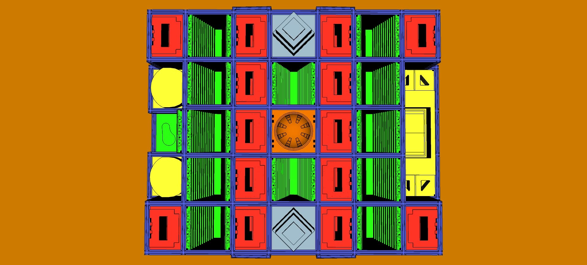
Here’s a top-down view of one of my most massive models to date:
I located this model in western Illinois, near the Mississippi River. The structure is surrounded by farmland, providing locally-sourced produce for use by city residents, and enhancing the sustainability of the city. Solar panels are planned for much of the rooftop space, to help provide for the energy needs of the public spaces.
In this model, aesthetics are secondary to community. Here’s the city program:
The orange structure in the center is the city administration, including public safety (police, fire, etc.). At the top is a domed auditorium for public hearings.
The 13 green structures are vertical parks, with 36 levels and balconies.at each level above the first.
The 2 blue-gray structures are office towers, each with 48 levels, 6 levels of parking and over 3 million square feet of space.
The 14 red structures are apartment stacks, each with 30 levels of apartments in 1-, 2-, 3- and 4-bedroom configurations. In total there are 9,240 residences to house more than 34,000 people. On one side of each stack are retail spaces for shops and cafes, totaling nearly 5 million square feet of commercial space. In the center of each stack is a large light well, allowing sunlight down to the staggered balconies of the apartments. These apartment levels are built up over 6-level parking structures for the tenants and visitors.
The 3 yellow structures are entertainment venues - on the east side is the stadium and on the west side are two performing arts complexes for theatrical productions and music concerts.
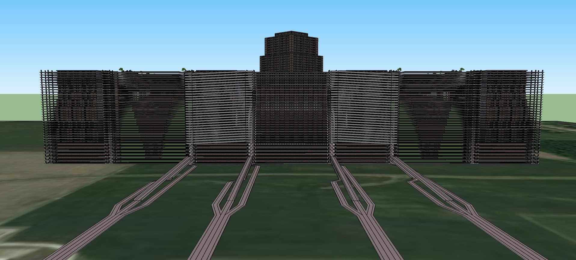
The idea here is that the city would be largely free from private vehicles. The residents would be able to take elevators or stairs between levels and could walk along sidewalks for a few blocks to get to wherever they were going. The streets would have public trams for those who need them. And there are bike lanes along each street in the grid, totalling more than a million and a half feet or 309 miles of bikeway.
2 Feeder roads lead to the north and south sides of the city. Each one is split into entry and exit lanes. Vehicle traffic can enter the bottom 3 levels of the city and make their way to a parking structure. Ramps within the parking structures allow movement between levels and access to the 3 upper levels. Deliveries from suppliers to the retail stores would come here as well. The ramps clinging to the sides of the city allow the public trams to move between levels.
As mentioned above, this is a massive model containing component definitions with more than 1.2 million component instances, encompassing more than 30 million faces, painted with 33 different textures. Seven structures were modelled separately and the brought together into this one model. Great care was taken to manage the performance load on SketchUp, and even then I needed to leave off some details in order to be sure I could complete the model.
I learned that it isn’t the size of the file that matters so much for performance as the complexity of the geometry that SketchUp must render. The file size of this model is 20.5MB; whereas I have other models up to 240MB which actually have better performance!
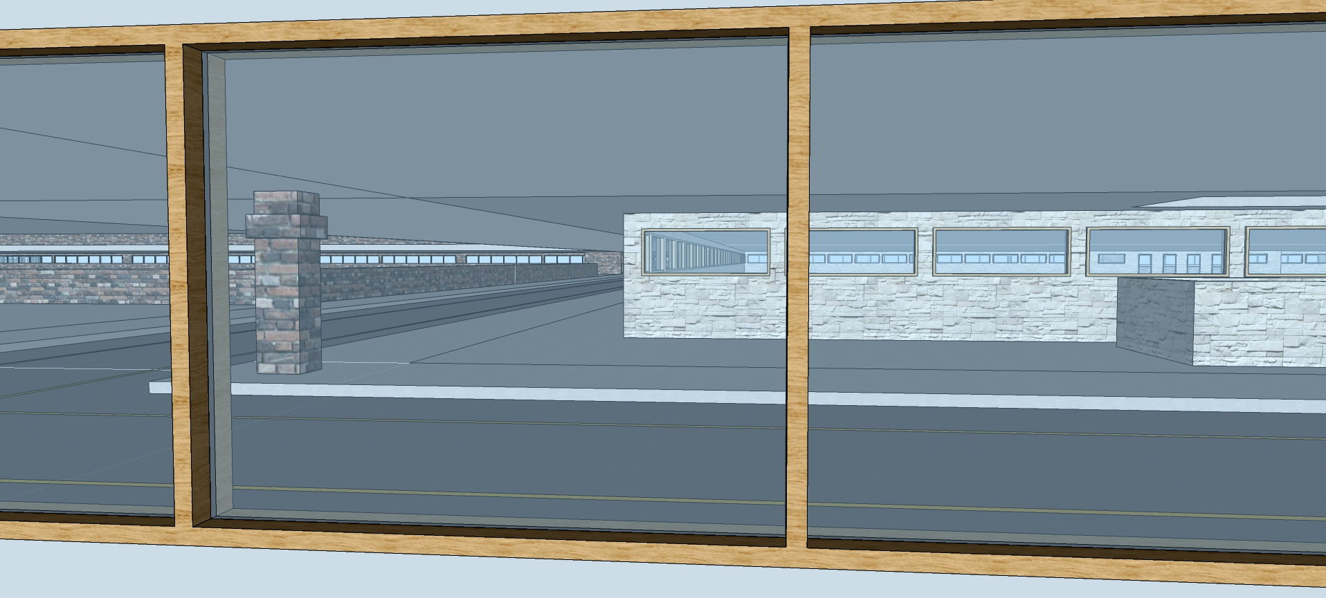
As seen in the post above, across from the apartments are park areas. Here is a view looking back from the park toward the retail spaces on one side of the apartment stack:
These retail spaces are designed to accommodate markets, pharmacies, restaurants and cafes, salons and spas, gift shops, specialty stores, along with clinics and financial services.
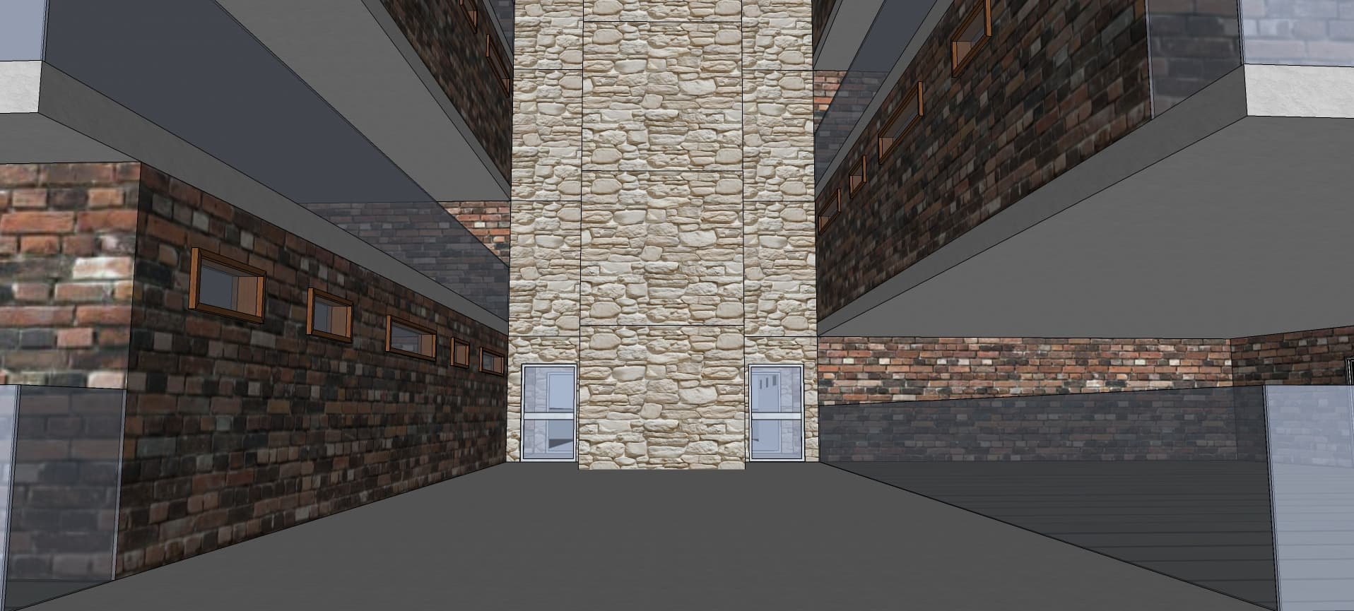
Here is a view from one of the retail spaces across to the municipal center on the right and a park on the left:
Cascading falls not only provide visual interest, but also add auditory interest to the ambience, cloaking other noises from the city. They also provide a bit of misting, which ensures enough moisture for greenery which is shielded from the rain by the levels above. These water features are fed by rainwater catchment systems within the structure of the city.
Yes, you’re right. I figured that out too late to fix it. Though it really depends on the seating arrangement, which is not visible here.
Please bear in mind I didn’t set out to design a stadium, I’m designing a city. The stadium model here is simply a placeholder. It says, “Stadium goes here.” Also, this is a concept model, not a model to build from.
The south-facing roof, which is oriented toward the rear of the home, has a larger surface area and a more relaxed slope, which is better for solar arrays. This shows the shadows on a mid-Summer afternoon. The circular pergola provides interesting shadows which shift with the sun through both the day and the seasons.
The site includes ample space for greenery and vegetation, though some of that space would also be used for catchment ponds and walking trails around the grounds.
Key:
LR - Living Room
DR - Dining Room
BR - Bedroom
MBR - Master Bedroom
ES - En Suite
K - Kitchen
U - Utility
The four end units have the same 3-bedroom layout. The two side units also share a 2-bedroom layout. So, this yields a total of 36 3-bedroom units and 18 2-bedroom units. Each unit enjoys generous balcony space and expansive views.
Thought I might add that when working on the above model, I added the vegetation last, because getting good-looking vegetation from the 3D Warehouse is hard, and usually adds a significant amount of complex geometry to the model, slowing things down quite a bit.
Also, I left those out when doing the light study, because I could not get shadows to display with the vegetation in place. Probably just way too complicated for SU to render. I even saw SU hang a few times while I was trying to sort out why the shadows wouldn’t show.
If you’re really determined to show the impact of tree shadows on your structure, keep the vegetation components as few as possible, and perhaps it will work for you…
The resolution isn’t great, and the drawings themselves are not very precise, but I thought I would give it a try…
I thought through a few approaches and did some research on this forum, where I learned that modeling a boat, with its continuously varying contours, is not trivial!
I decided to try an approach where I created a 3D solid with the profiles on 3 sides:
I thought it wasn’t bad for a first attempt, but I saw 2 areas that needed improvement: I needed to hollow out the boat and I needed to attempt to show the strakes / planks on the side. For the latter, I felt it unnecessary to go full 3D with this and simply show lines to give the impression.
Here’s my second attempt, following the basic procedure above, but adding the strake lines to the side profile and hollowing out the top profile:
After even more tedious work cleaning this up, it was clear to me that there had to be a better way. And I was still not satisfied with the bottom contour…
I spend a lot of time redoing the process with a better bottom contour, and then realized it would save me half the time of clean up if I made the simplifying assumption that the hull was symmetrical, lengthwise. (This is not guaranteed, but seemed reasonable, given the diagrams.) So I had the following:
To make things simpler, I built the keel separately from the rest. (The drawings were inconsistent about the keel, with most drawings showing the ship coming to a sharp point fore and aft, but an actual photo of the reconstructed ship showed the keel was not like that. Mine is probably too wide.) Another simplification was to not use a hollowed out top profile as in my previous attempt. Instead, I scaled the half-hull down slightly, and the intersected it with the full size hull to create the geometry for the interior side of the planks:
Even though I had View > Hidden Geometry selected, some of the hidden lines were not shown. In the above image, you can see that I have selected a face, but its boundaries are still hidden. At the same time, many other hidden lines are (correctly) shown at the bottom of the image.
I have no idea what is causing this, or how to get the hidden lines to show. This was VERY annoying while I was working on the model, and really added to the tedium of cleaning up extraneous lines and faces.
My motivation for modeling that boat last month came from a house in Viet Nam that I saw online. This house featured an actual boat suspended over the first floor:
I was inspired to try something similar with a boat from a western-culture background. I wanted something with dimensions that could support a couple bedrooms while not being overly large or complex, so I decided to look into a Viking long ship (see above).
The natural choice for a structure to house such a boat was a Viking long house. I was able to locate numerous images to inspire me, including…
A row of clerestory windows along the western wall allows more light in at a high level. All of the rafters and wood trim on the house are dark-stained oak, matching the boat hull, which will be seen below.
A child’s bedroom is located at each end of the boat, with sail cloth used as curtains to give privacy, while the “cabin” is open to the rafters above.
Many thanks to all those who offered suggestions about how to model the ship’s rigging. It is likely an anachronism for Viking ships, but I use it here to prevent young ones from falling over the side in the shared central space of the boat.
Here is the great room, from the back, prior to adding furnishings:
A sofa is strategically located below the rudder, which hangs a bit low. People should be able to sit below it without a problem, and the sofa prevents anyone from walking into it.
In the center, under the keel of the boat, is a kitchen island, with the kitchen on the left and the dining area on the right. The blue wall and the dark blue tile on the island provide a sense of being below the water line.
The front end of the great room is an area for entertaining guests, and has a nice view of the garden through patio doors:
The left side of this hall provides access to the primary bedrooms and a shared bathroom. The stairs lead up to a landing with access to the boat, as well as a bathroom. Beyond the stairs on the right is the utility room and a half bathroom which guests can use.
View of the steps which carry us over the “gunwale”, the upper edge of the boat’s side:
The single bed is suitable for kids. The curtains, suspended from rigid wire slung between the rafters, can be pulled aside during the day to allow more light and ventilation into the cabin. The door is also curtained.
The famous author, J.R.R. Tolkien, was a professor of linguistics, with a great interest in Scandinavia. He was also an artist, and all of the artwork shown here is his.
Many of the furnishings in the house and all the vegetation were found in the 3D Warehouse over the course of the past 15 years.
This house is envisioned for a mountainous region in the tropics.
The angled roofs allow heat to rise in each room, and operable clerestory windows allow the heat to escape, while allowing indirect natural light in.
The house is situated on a corner lot with the entrance facing the quieter street, while the garage and driveway face the slightly busier street. The private areas of the house are along the left side, facing away from the busier street.
The double-doors in the front are of Chinese design. The leaves of the maple tree coordinate with the red metal roof and the red pavers of the walkway.
The courtyard provides central circulation among the rooms, covered by a light-colored canvas awning. A fountain in the courtyard aids in natural cooling (and inhibits mosquito breeding on calm water).
Doors and vegetation, as well as the fountain(s) were obtained from the 3D Warehouse.
Previously I have done a couple homes that are inspired by ethnic cultures, but intended for American sites. Continuing that, here is a home inspired by Arab culture… Beit Al-salam:
This home is envisioned for a southwestern location, such as north Texas. The vegetation in the landscaping was chosen to reflect what would be found in Arabian environments and be able to grow in a hot, dry climate.
The front window treatments reflect rich mashrabiya traditions.
This side has little glazing, with the exception of a balcony door off the master bedroom and clerestory windows under the eaves, in order to reduce solar gain.
On both the south and west balconies, hardy succulents provide a view of greenery out the window without requiring lots of moisture.
Above the 2-car garage, a deck is overshadowed by a pergola with an arched shape that is echoed in other parts of the home. This is a place to catch an evening breeze while being shielded from the afternoon sun by the upper floors.
The front walk has stone pavers that match the siding of the home.
An internal courtyard provides a light well, brightening the interior, as well as allowing heat to rise out of the lower floors. The mashrabiya screen design is continued from the outside. Arches are another nod to traditional styling.
Just inside the entry, to the right is a dining area, with ornate ceiling, followed by the kitchen. The beauty of the natural world is symbolized by the green countertops, along with the green pillars, and the blue ornate ceiling in the front sitting room and hall. The golden details add a touch of luxury.
Each successive floor has yet higher ceilings, allowing the heat to rise away from the occupants. Clerestory windows allow more light in on the east and south sides, moderated by the eaves outside.
Looking up from below, we see that there is traditional calligraphic lettering on the skylight.
Unfortunately, the lettering left no shadow in the native SketchUp rendering. As it is, I believe producing this lettering was the most time-consuming part of this modeling experience… see
I finally produced it by importing an image of the text and hand-drawing the outline, before using the Push/Pull tool to make it 3D.
My process for this model (as with many of my models) began with a rough layout of the rooms, using blocks which represent typical sizes of each room type:
Five bedrooms, along with three and a half bathrooms, provide ample space for a large family. The attached garage as well as the den/home office are further amenities of this modestly stylish home.
Further credits:
All vegetation was obtained from the 3D Warehouse (and usually modified a bit), including:
Desert Rose and Vase - Star
Yucca Tree - International Treescapes, LLC
Hanging Succulent - Vickey J
Succulent Euphorbia in Vase - Herbert Figueira
Low Growing Juniper - CherryBlossom
Generic Acacia - Maverick F
Jasmine Vine - Matthew V
White Sage - Daniel M
Desert Willow-Chilopsis Linearis - Rich E
Also, a Chinese Style Door was downloaded from 3D Warehouse and used here, as it has a more general eastern style and subtly recognizes the rich history of trade between the Arab world and China.
After working to get a pentagon of appropriate size, I then rotated it with copy 6 times about one of its corners. (The one highlighted in yellow is not the original copy, but rather the 4th of the 7.) This gave me the outline of the structure, and the lines converging at the center suggested to me the ridgeline of the roof.
I decided to give this house a brick façade, but instead of using “Standard” bricks, I used “Norman” ones with a darker tone. The home is situated on the corner of two residential streets.
Each bedroom has its own private balcony, and the master bedroom has an en suite with a discreet view out via high windows, allowing a view of the sky.
Here a different brick arrangement is used. The fence is not intended to provide a security wall which separates neighbors, but rather to mark the boundaries of a space and give structure to the yard. Again, the texture transforms a simple brick wall into something more interesting.
The most complex arrangement of bricks was used toward the street. It is highly textured, and moderately porous, and is low enough to allow the house to be seen while still defining the space.
Interior View of the First Level from the Entry to the Back:
The coat closet door to the right of the entry is visible toward the far right of the image. This is the view that will greet arriving guests. At the far end is the kitchen and the entertainment zone.
Interior View of the First Level from the Back to the Front:
The transverse view looks back toward the dining area, the formal sitting room, and the front door. The stairway divides the entertainment zone from the formal sitting room, which is open above to the roof. A half-bathroom is to the right of the stairs.
Windows at each end of the hall give plenty of natural light. The front bedroom is to the right, and the two back bedrooms are to the left with a shared bathroom between.
Credits:
All of the kitchen cabinets and appliances were downloaded from the 3D Warehouse many years ago, as were the seating and doors.
Standard Gas Grill Center - Challenger Designs
Small Maple Tree Summer - Jeffrey C
Arvore 2 - Gabriel Felin
Cypress Tree from Hilly Plain - Johnathan G
Bamboo Tree from PLANT COLLECTION PART 1 - Christ H
Flowers from Shrubs - Diana
All borrowed components were customized for use in this model.
I recently saw a news item (which I can now no longer find) about a project to produce modern, sustainable architecture for Dakota people. This got me thinking about how I might design a community based on their values and traditions…
Proposed Dakota Village - View from the North East:
This village is envisaged to be built on reservation land here in Minnesota with simple materials and incorporating traditional design elements. Here are shown homes for 21 families, though additional homes could be added in an outer ring for perhaps 30 families.
Each house would be shaped like a tipi, but made with more durable structures as a reflection that the people no longer have a nomadic lifestyle. A utility area is in a cellar space below each home. In-ground geothermal systems could be used to keep energy costs low. The structures would face east, toward the sunrise and away from the cold north and west winds, in keeping with tradition.
In the center of the village would be a meeting house, with an outdoor gathering space on the roof. Inside could be smaller meeting rooms, tribal offices, or even a clinic.
A central platform is surrounded by a circular fire feature, which could provide some warmth and/or light for evening ceremonies. The seating would accommodate about 215 people, which should be sufficient even if an outer ring is added.
Access is granted via trap door to a space with an outdoor fireplace. Canvas wind blockers are installed on the railings on the west side, and more could be added.
Here, the sofa cushions are adorned with traditional beadwork. A fireplace allows heat to flow toward the seating area, the dining area and even the master bedroom in the back. The opening on the kitchen side allows for food to be cooked over the fire as well, if desired.
A quilt on the bed features a local design. The door in the back provides access to a shared bathroom. A high window provides natural light while maintaining privacy.
Again, a locally-produced Star Quilt is shown on the bed, and a high window provides for light. Celebrating traditional designs would hopefully encourage the preservation of the Dakota culture and heritage.
Final note: if there is one thing I would have done differently in hindsight, I would have made each home a bit roomier in diameter, so things wouldn’t feel so cramped inside.
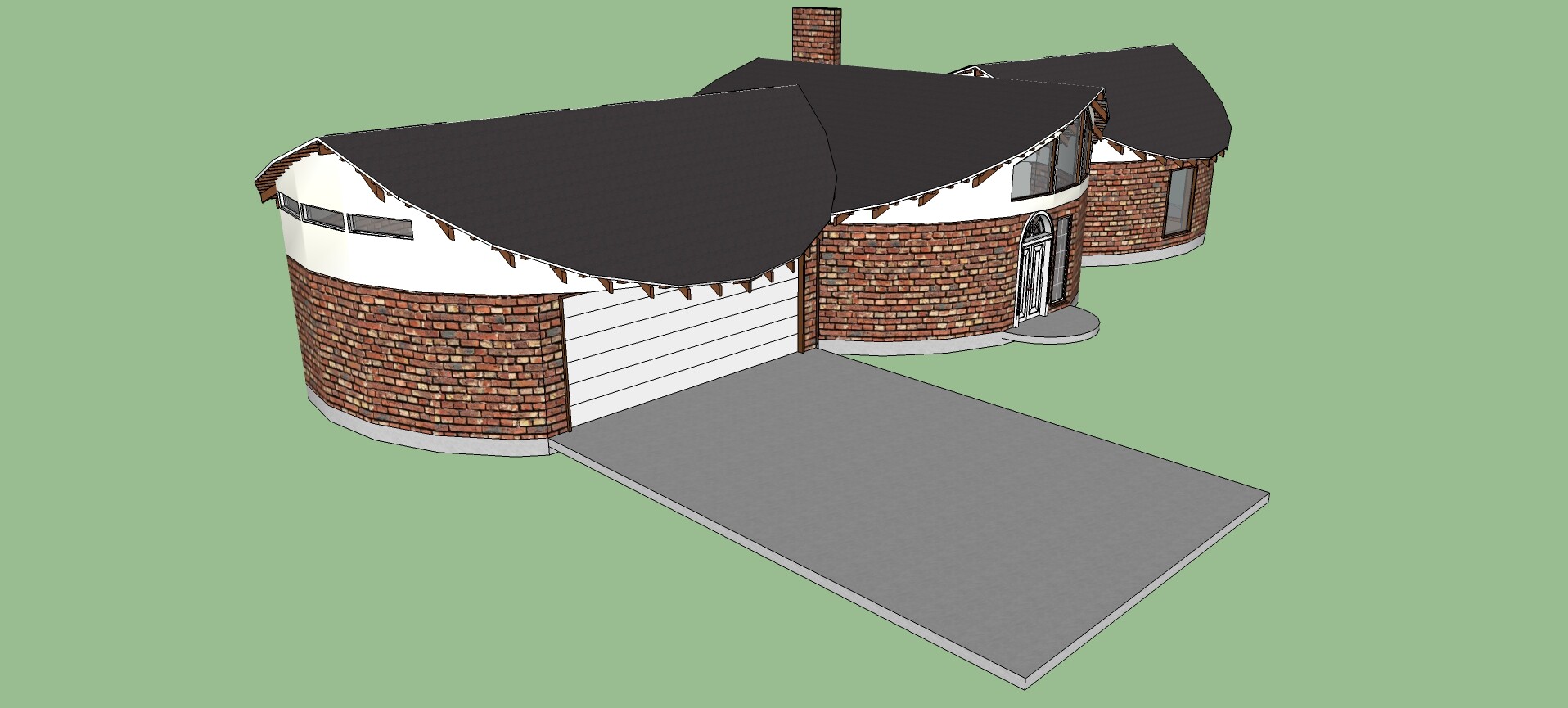
The lower level is clad in multicolor brick which responds to the natural stone of the region. The second level is clad in darker wood, which relates to the surrounding forest. The darker tone of the wood also absorbs more of the sun’s heat, since this is a cool climate even in summer.
Each bedroom opens on to a balcony for enjoying the outdoors whenever the weather allows. Semicircular bays on both levels allow lots of natural light in
The north side of the house looks out over a placid lake. The surrounding evergreen trees screen the home from as much of the cold northern winds as possible and the jacuzzi on the second-level deck is lifted to receive as much sunlight as possible while still being in the lee of the house.
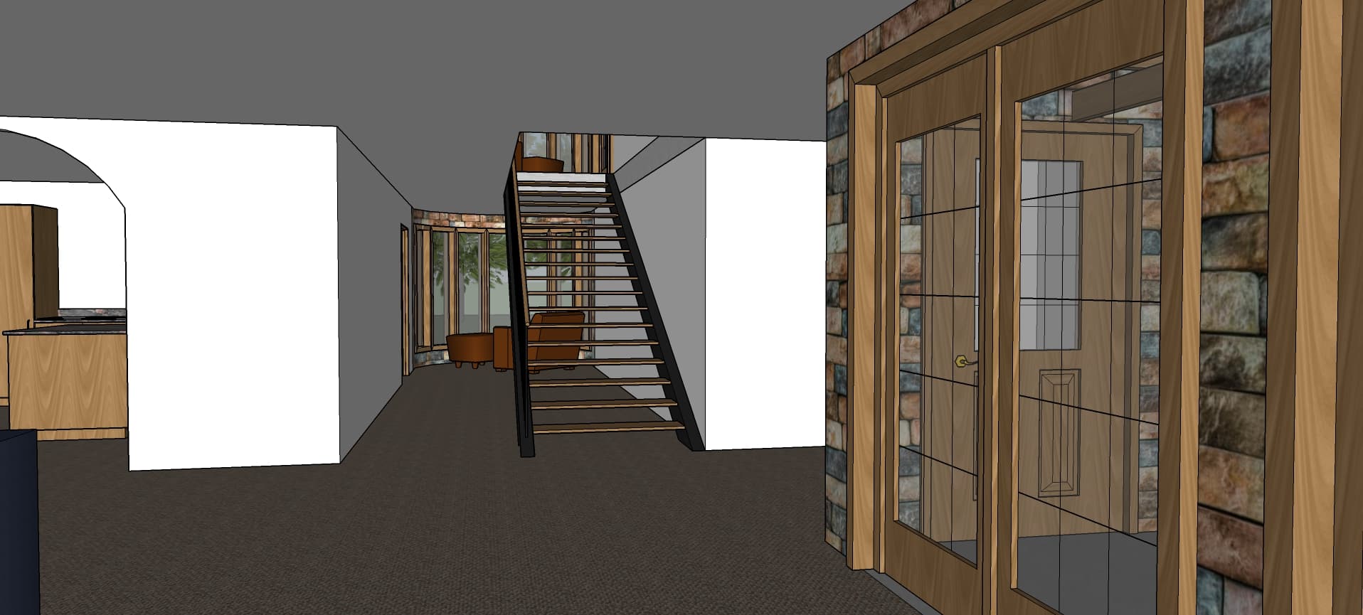
Here the fireplace can be seen on the far right wall. The door leads to the half bath. Around the corner the fireplace area doubles as an entertainment area.
View towards an additional sitting area, the Kitchen on the right and the Dining Room beyond:
A hallway between the kitchen and garage allows access to the utility room beyond the kitchen, as well as a private sitting area for quiet reading or reflection.
Looking back toward that same sitting area, there is plenty of glazing along the southern wall to allow natural light and warmth in. Outside those doors is…
The two full bathrooms on the upper level reside in semicircular bays. Here, a soaker tub is just around the corner from a curbless walk-in shower. Higher windows let in in natural light while preserving privacy.
The outdoor fireplace can be seen here just outside the master bedroom and another bedroom. This allows for views of the lake and enjoyment of the outdoors on cooler autumn evenings.
[*All furnishings and trees were downloaded from the 3D Warehouse.*]