My very first message here was about that, when they announced the BingMap photos, I came and said “yeah, thanks, but meh, really meh”
check the Swiss examples I gave back then, they are bluffing. Ah, the things you can do when you hoard gold… for centuries
In Su’s tool, the photos (in france / europe) are average at best, and often outdated. and I’m curious as where the 3d data comes from, I get why forests and buildings can make it look bumpy, but water ?
If something like it would be helpful, I could possibly strip that tool out and share it. Otherwise, check in the Extension Warehouse for, “Contour lines”.
The 3D data comes from Trimble Maps. They aggregate a variety of sources for us with various resolutions and accuracy.
The altitude data varies greatly by country, it can be from various technologies from different years, some of which can cope with water well, some not so well!
Note that we have not changed the 3D data for the labs version of add location - what has changed is that you can choose what resolution to import the terrain at whereas before it varied depending on the size of the import area.
With respect to reading other sources of data - that would indeed be a large project. Currently the best way to make your preferences known is to put one clear desire in the in-app pop-up survey, as there are so many other improvements that we would like to do, but we have limited resources!
Yeah, that’s why I say that the only / best reliable source you can find is not from a global company but from a national source.
You, cadmapper, placemaker… it’s all the same, on one hand you give us a list of possible sources you use, but it really varies from place to place. Cadmapper uses USGS and NASA data for the US, so off course it’s better :).
And I criticize the photos (their age mostly), but funny thing is, while google map 2d has recent photos, their 3d version suffers from the same problem, near me, the 3d dates from 2019 (more or less), similar to bing -_-"
yeah, I noticed afterward, the grid is thinner, so where it used to be a “soft hill” topography, it looks “grainier” now. making the issues more obvious to notice.
whaaaaat ?
heheh, I don’t expect trimble to go grab accurate 3d data from each government geographic agencies in the world. keeping that updated would be a nightmare alone. Plus all the languages…
I wonder if the EU has a global geographic thing. every country in europe does, but do they centralise data ? if so that would make it simpler.
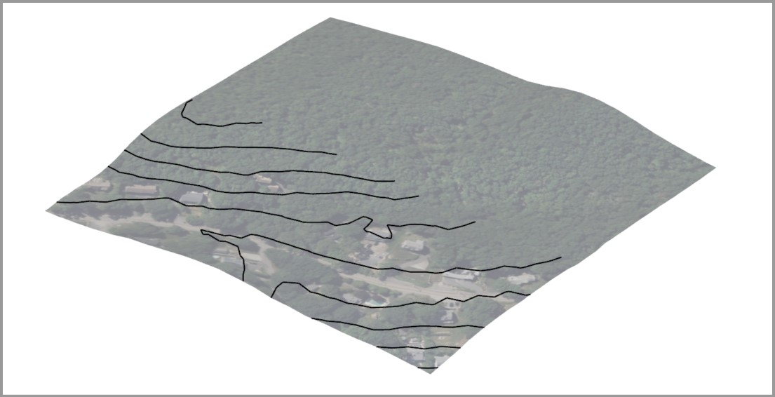
So while the accuracy of these aren’t great (generally speaking its accuracies are referenced in “meters”) I’ve actually used the image objects that are pulled into this to create elevation contours for a more traditional look:
Add 3D terrain via the extension/tool you mentioned
Create a flat plane that is relatively the same size square as the area imported and make it and it’s borders an object,
Move it to the lowest elevation point in your terrain,
Make copies at equal distances (in the example below they’re 10m apart)
Unlock the imported terrain (right click → “Unlock”)
Select all (terrain AND multiple flat planes) Right Click → Intersect Faces → with Selection
Delete or Hide the flat planes, and you now have your contour lines!
What you want to do is look for a GIS database for the area you’re looking at, and downloading the elevation contours in .dxf format. If you can’t do that, I have replied to another who mentioned the terrain import function and a method I’ve used for rough elevation contours, however I would be cautious as to the accuracy of those elevation values. They’re usually only accurate for 1-3 meters.
I would start by looking at the USGS website, even if you’re located outside of the US they may have the data you’re looking for. You’ll want to look at “Digital Terrain Models” (DTM) or “Digital Elevation Models” (DEM), NOT “Digital Surface Models” (DSM) as those will include surfaces of man-made structures.
Hello and thank you for your response. I probably wasn’t sufficiently accurate in the formulation of my question; the intention was to ask if anyone might know of a quick and simple - yet sufficiently accurate - method for extracting contour lines from a standard map - if a map is all you have available as data.
I am aware that one can obtain map data from various sources and in different formats, but common to all of these is that they either a) cost money, or b) take some time to obtain - and if you’re just making a quick model of a terrain piece (typically 500-1000sqm for a house plot) in a bidding phase, it’s easyer to download a map excerpt for the address from the internet and take the contour lines from there.
Anyway, thanks to all of you for valuable input