BTW, I phrased my post as a question because it seems to me that this exposes a logical flaw in how SketchUp is handling non-visible content. I don’t think non-visible content should affect clipping or operations such as orbit, but it evidently does. Said the other way around, it strikes me that hiding or tagging non-visible should be a way to avoid clipping. Things that aren’t visible shouldn’t impact viewing of things that are visible.
1 Like
I think that turning off a tag only affects the visibility. New geometry inferences objects on hidden tags just fine.
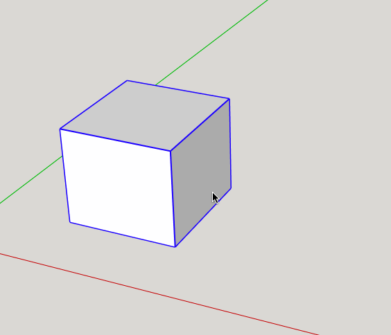
There is something weird that happens! If you generated inferences from vertices on an object and then make that object’s tag non-visible, those inferences are remembered by the engine but vertices that were not previously inferenced are not found. In the attached, the box is a component. I first activate the line tool and float it over two vertices to get inferences at them. Then I make the tag of the box non-visible and try again. As you can see, I can still get the previous inferences, but I can’t get new ones to any other vertices of the non-visible box. I find the inconsistency to be quite confusing.
I did test the SketchUp car park (or nearby anyway), and I think the clipping amount was about the same as your location in the UK. My guess is that it’s the presences of any geo location, and not so much where it is.
It’s not that the model is geolocated as such, it is the terrain and snapshot components that cause the clipping.
There is no reason not to store those in a collection and remove them from the model while working. They can then be dropped in when needed.
Or can you just geolocate and delete the terrain?
Yes sure, if you don’t want it delete it and the shadows will orient to the location.
If you want your template to reflect your general location, then yes, delete the terrain, and snapshot, then purge those layers/tags make any other changes you want to the style then Save as Template and give it a name, probably something like Local, You can set it to be your default.
It’s only the few that you pointed at with the ‘Line’ tool. Clear them from memory by pointing at several now visible new inference points.
You are right that it is somewhat inconsistent. Memory should be cleared from invisible inferences when disabling tags.
Recently (a few weeks ago) there was a discussions about this issue.
It’s NOT whether or not Geolocation, per se, as a feature is on or off, it’s the HUGE size of included terrain image. You claimed this was a simple test model. You were mistaken, and that’s part of the problem. It’s a very complex model that stretches the limits of the system.
You are getting clipping INCHES from the camera because the program is having to compute the relative positions of objects that are MILES away. It’s kind of like a form of “resolution”.
Cliping is how 3D display calculations deal with the fact that there are only so many digits of precision available in the calculations. There are both near and far clipping planes, and it’s the proportion of the distance between them, on an exponential scale, that determines the precision required, or conversely, that is limited by the precision available.
Moving the near clipping plane from 1 inch to 2 inches away can allow the far clipping plane distance to double. Normally SU allows you to get the camera a fraction of an inch away from whatever you are zooming in on. And it can do that with a far clipping plane that is hundreds of feet away. To accomodate miles of distance in the far clipping plane, the near clipping plane has been moved out to where you notice it.
I hope this helps,
August
2 Likes