I’m trying to create a site plan for a 3/4 acre parcel. All I have to work with at this point are the 3 files attached. Is there a process whereby I can create a site plan with just these 3 docs? If so can you point me to the steps needed to achieve that.
If not can you point me to a source of a better topographical map or process to create one. The topo I have here is from a USGS Topographic map source. If I try and zoom in closer it just becomes very blurred. I’m willing to use a paid source like ArcGIS if that would help, but I honestly do not even know what they offer.
Bottom line is I need a basic process to how to go from nothing to a site plan with a basic topographic 2d map and my proposed house and septic system and am struggling with how to go about this.
Any help would be greatly appreciated.
The three docs you have in hand are of little use.
They’re merely simplified representations of a legal Plat of Survey prepared by a Licensed Surveyor.
Visit your County Surveyor’s Office to obtain a copy of the recorded survey(s) of the property.
Occasionally, a survey includes topographic contours.
Here in the UK we use Ordnance Survey maps that not only show features like buildings and roads but also contours for vertical data. The spacing of the contours depends on the scale of the map. I imagine that is what you mean by a 2D topo plan. I presume something similar must be available Stateside.
You don’t specify exactly how you want to use the plan. I’m guessing you want to show the position of the new house and septic tank. The contours would help work out how the land falls and so where the tank might go. Is that right?
You can redraw the first image using autocad. Do this in the correct scale and you will come very close to the actual situation. You can also use the google earth contours and extrude them in Sketchup to get the approximate slope of the terrain.
Thanks. I guess the first thing I should do is go to my county offices and see what they have to offer.
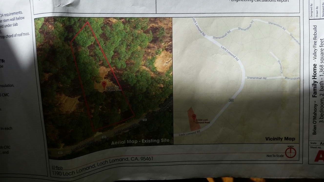
Below is what I’m trying to reproduce. I borrowed from a friend who just got his plans approved and permitted. The site plan page has a basic map with contour lines and some elevation info, and the position of the house, septic and leach field.
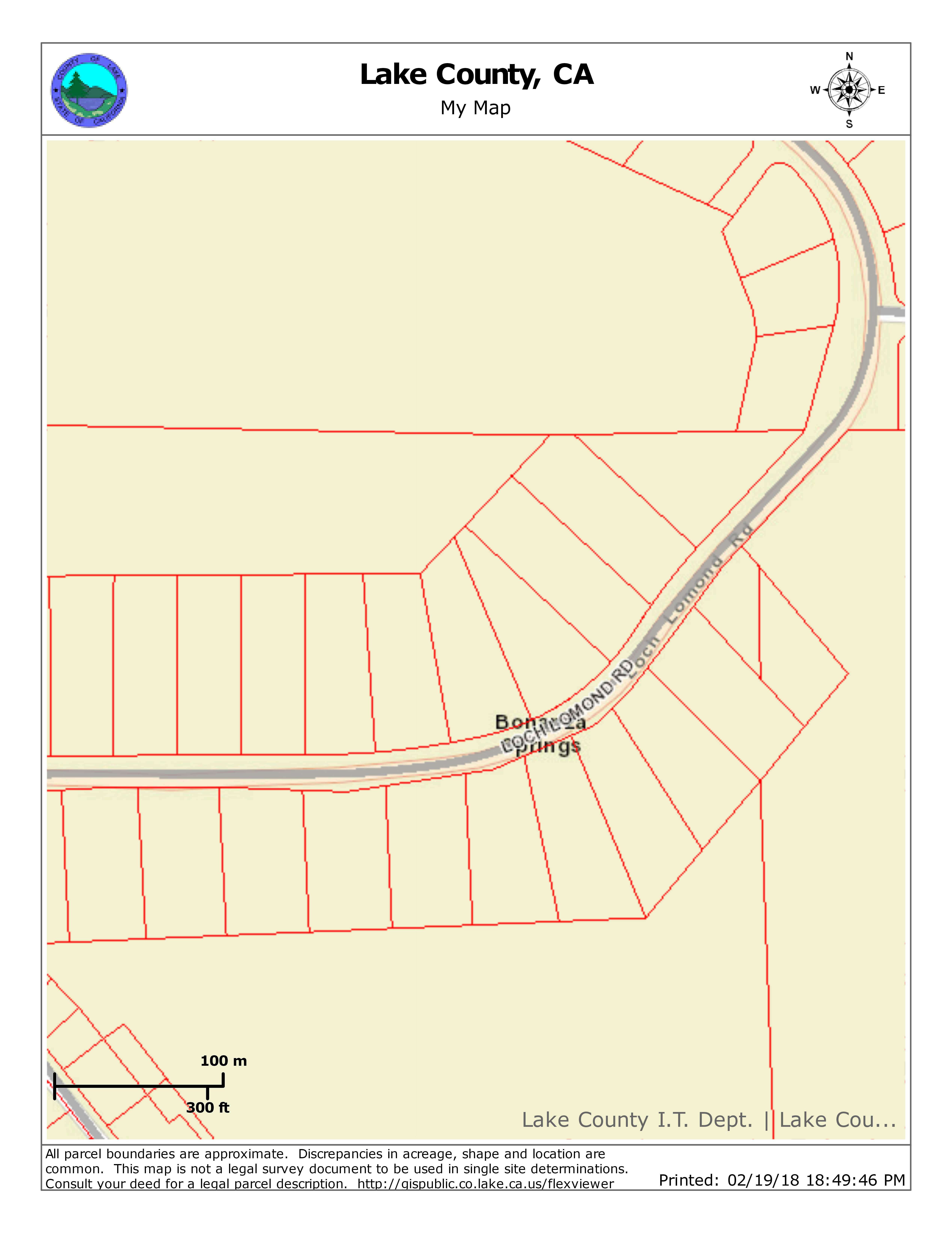
So, I just got back from the county assessors office and they said the property has never been professionally surveyed. And they have no map other than the simple outline of the property with the lengths and degrees of the borders.
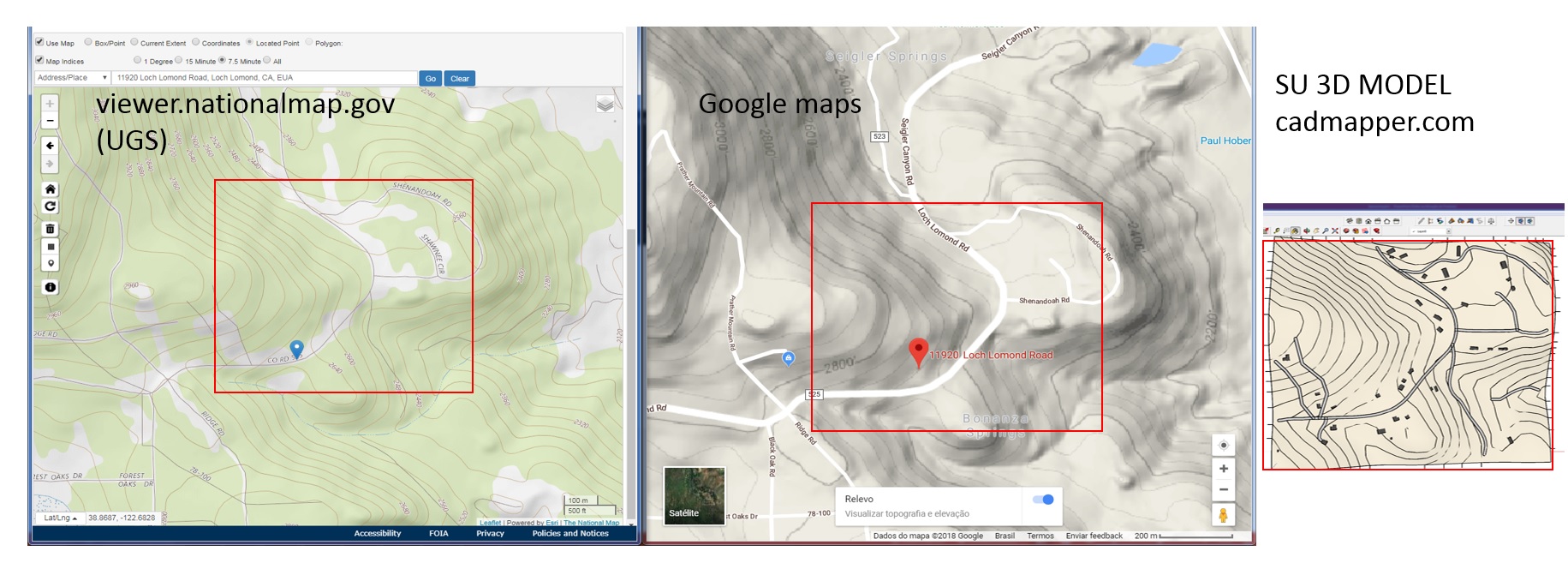
That poor quality contour map I have here came from some USGS source website coupled with google earth. The map guy at the assessors said they have much better quality digital ones. Does anyone know how I can get one of those? Will ArcGIS have that kind of quality?
I would start by asking him. The guy who handles the GIS system for my town once burned a file to disk with a few layers of stuff for my neighborhood. I think I had to sign some release form.
No, ArcGIS will not give you better quality in contours.
If you have the legal description, it is easy to draw the lot. Based on Google Earth or Topozone information, you’ll have the approximate slope of the region, so you can draw level contours.
For approval, is geo-referencing required?
What information is missing for you to produce a project like that of your friend? Let’s see the files, maybe we can help you.
If they have the all the property boundary lengths,degrees/minutes/seconds (heading)
Something like: S 45º51’0” W 75.0’
Then you can accurately plot the property boundary.
Keep in mind you will have to determine the building setbacks among other potential restrictions.
I think there is a SU plug-in that can do this, otherwise some of us here may be able to do so for you.
I did talk to him. He said go online and find a USGS website and figure it out. My 3rd photo from the top is from a USGS source. If I get a little closer in distance it becomes very blurred.
The guy alluded to USGS does have topo maps that should give good quality of a 100 x 100 foot plot, but I’ve search the interwebs a ton and have not found it.
Oh, I think USGS is a lot bigger scale (i.e. blurry for your lot size) compared to what my town’s own GIS system has. Much of the time, I have an A-2 survey from a licensed surveyor for a lot, but not always. Nothing beats that, but it’s usually $1~2k or more to get that done.
I’m sorry, I don’t know much about mapping or geology, not sure what you mean by “batch” and “geo-referencing”. By “legal” description do you mean the dimensions of the property lines. Here is what they gave me on a map so tiny I have to use a magnefying glass to see the numbers. But on the property borders it has a number in feet and degrees like: N84°05’08"W and 168.13 ft.
I would very much appreciate your help, admittedly I’m new to topo maps and site plans. I can make the map with the position of the house, setbacks, septic and leach field, what I need is the topo map to overlay my outline map. In other words, I can make a simple map in sketchup with lines to scale (like 1:20 - inch:feet) given the distance in feet I have of the property lines, and in that put the representation of a house and septic and leach field, but I need to have the topo information in that map also. The topo is the part I have no idea how to do.
Yes, exactly. You can redraw your property lines based on those numbers. I just did exactly that this week on a project. Keep in mind that only helps you with zoning issues such as setbacks and coverage. Contour lines and topography are a separate issue.
For the sake of full disclosure, I do that kind of 2d drafting in PowerCADD, and import it to SU via dwg files. I’ve never used degrees, minutes and seconds in SketchUp, and never tried. Can you?
I, or another licensed architect, could develop a site plan that meets the requirements of local authorities. I am surprised that your California jurisdiction can’t provide an accurate plat map of your property, though.
Municipalities, counties, or voting districts often make such information available at little or no cost to taxpaying residents. A scaled plat of your site will show the overall lot with property lines (including dimensions and declination), improvements such as buildings, freestanding walls or fences, natural features such as streams or lakes, significant forestry stands, Rights-of-Way, legal easements, etc. It may also indicate building restriction lines or setback requirements, but this information is usually provided only in surveys. None of the info on the plat will offer slope or grading data, however.
An accurate survey is required to obtain topographical data, but, it may be possible to get the contours from Google Earth or other sources. Assuming that professional assistance is being eschewed, I suggest you ask the local code and permit review office to locate and provide the relevant property plat information and then inquire as to where any publicly available topo data can be had.
I have experienced some success in developing site plans with such survey oriented declinations using SU alone.
No, actually it isn’t! I would be happy to higher your services or anyone elses, but it sounds like you cannot provide the missing piece that I need.
A little while back the county started requiring “slope and grading data” i.e topography mapping. This is the piece that is missing and what I need help with at this point.
While I admire your DIY spirit, I think it would be wise to hire a Surveyor.
Bring the Surveyor, your Builder and the Septic System Plumber together to coordinate the overall plan.
Sketchup does not work with angle surveyers, only with grads.
The easiest way is to draw in autocad, but if you can do this, I’ll tell you what can be done with the top map.
The files available online, have basically the same precision (30m). They are not millimetric surveys, but depending on their use, it may be good.
Comparation:
As I said, the resolution is 30m, if you have a smaller land than that, the contours will only appear as straight lines, but if you go to the terrain, you can improve this by adding the planes, paths, stairs, slopes, trees and “create” contours a smoother and more realistic.
I’m in the right way? Is that what you want to do?