I’m an architect and have been working with Sketchup for quite a while, accumulating experience with Sketchup, Layout and Render software from conceptual stages, building permits and construction documentation, as well as archviz.
I’ve also been using Photogrammetry for context, site and building modelling, as well as material authoring.
My work is generalistic and a lot of knowledge I have about Sketchup could be applied to various fields. I’m thinking of focusing on the fields of architecture, interior design, landscaping, urban planning and engineering, of course, but I’m also thinking on how to share this knowledge in a dynamic way to other fields.
I also know that there’s a lot of tutorials and workflows, books, videos and sources of knowledge in a lot of places online, most of these free, but I’m wondering what is lacking in terms of tutorials or in terms of tutorial methodologies that people might have difficulty accessing to.
So, the questions are:
What would you like to do with Sketchup?
How would you like to learn it?
Best regards to all and stay safe.
Note: I don’t know if I can post this here. If not, please tell me and I’ll remove the post. The thing is that this seemed the best place for this question.
Like you, I am a long term user of Sketchup and Layout. I reckon to be pretty proficient but I can still learn new tricks.
The tutorials I have seen that appear to have been created by the Sketchup team are very good but they only go so far. Very useful to first timers but not so much for the experienced user. I would like to see that series extended for intermediate and experienced users.
Personally, I am interested in getting into rendering. What you can do in SU itself is pretty good for most purposes, but it is nowhere near photorealism. Software and hardware have got to the point at which it seems possible to create truly impressive output without huge outlay. But it is still a bit of a minefield to know which renderer to choose, what you need to run it, how great the learning curve is, and so on. This may be beyond the brief you have set yourself as this is a Sketchup forum, but as you mentioned rendering I thought I would comment.
I would be very interested in learning about your workflow for this. Don’t need a full-blown tutorial, just a higher level description of the steps and equipment/software required.
Rendering is always one of the most searched for subjects.
There are very different approaches to it and you do seem to seek realism.
It’s perfectly achievable in Sketchup, but it would be wise to extend Sketchup with several other software tools besides the renderer of choice, which should be an offline renderer for now. You will need a lot of high quality model assets, high quality texturing and a very specific modelling workflow depending on what you want to achieve.
This modelling workflow isn’t the same kind as what is used for an architectural model so a tradeoff must be made there. Either aim towards realism or towards a desing iteration and documentation model.
I use a specific workflow that blends both up, but requires a lot of hard rules to follow. It creates realistic results and doesn’t compromise design iteration or documentation and architectural presentations.
If you’re working solo on both project and rendering the tradeoff I’d recommend would be to sacrifice a bit of realism. If you have a team, nowadays, you can have both things happening with the same base model if you have a very coordinate workflow and asset management.
That would be a tutorial I could develop.
Would that be something you’d be interested in knowing more?
The best process for this is to have the survey made by laser scanning and generate a model from it as accuracy is much higher and results are georeferenced.
However, most clients I work with are not interested in doing it so I use photogrammetry as a complement of traditional surveys that are usually delivered by clients.
I’ve been using drones for bigger projects and phones for interior refurbishments or smaller projects.
Here we also need extra software for point cloud and model reconstruction, and I highly recommend plugins for sketchup to deal with pointclouds and model in sketchup with them.
Yes. I do work solo and wouldn’t be able to charge a client more just for a pretty picture. I see anything I do with rendering outside of Sketchup has to be just to help a design be more persuasive, but I can’t afford to spend hours turning something that is acceptable in Sketchup into something that is amazing in a renderer. Similarly, I can’t justify the capital cost of state of the art hardware to run it.
In short, any tutorial that gets me to the next level from SU rendering to something more advanced (using, say, Podium or V-Ray) would be welcome.
It’s a tough request. I’ve been there myself and done all I could to be effective in both ends. Right now we can achieve what you want, but it’s demanding.
People that need top notch renders and don’t want to invest time/hardware, usually pay for archviz.
What we gained with the process was a better design workflow because of archviz. It’s become conceptual more than presentational and help us explore architecture in new ways, instead of only using it for presentations to clients… If that’s understandable it made us better architects.
Simon, I suspect your client base is similar to mine but perhaps I do more terrace work than you being in Norwich (?) where photorealism won’t necessarily be of much help or of interest to my clients.
I think the type of project where photorealism comes into play is a project where a ‘proper’ architect is involved and there’s scope in the fee for it.
You are right on all counts. I am more into country houses than town houses.
I suspect there is never “scope in the fee” for photorealistic rendering outside commercial projects or very high end domestic ones. I cannot ever imagine being able to say to a client “I can produce drawings that will tell you all you need to know including quite realistic perspectives, but for just a few thousand pounds extra you can have something that looks almost exactly like the building you will shortly be able to look at in the flesh anyway.” I am sure such output can sometimes help persuade clients and planners to pass something they might otherwise be doubtful about, but they can also bring a certain amount of suspicion about “pretty pictures” (we are Brits, after all). So it’s more about personal satisfaction for me and there is a limit to what I would be willing to pay just for that. So rendering software has to be easily affordable and easy and quick to use. It is none of those things yet but we would have said that about CAD not that long ago!
Hi Simon,
Have you looked at Twinmotion or Enscape? The results are reasonable in terms of realism with a small learning curve. I use Twinmotion with my clients and you are correct in that it helps them to understand the design. Once you have built up a library of textures and PBR maps the turn around is relatively quick.
This was a planting plan that I pulled together for a client.
I always look to learn more on site work. I would like to see more methods that work in an organized manner for well organized models, because it seems I do it differently every time!
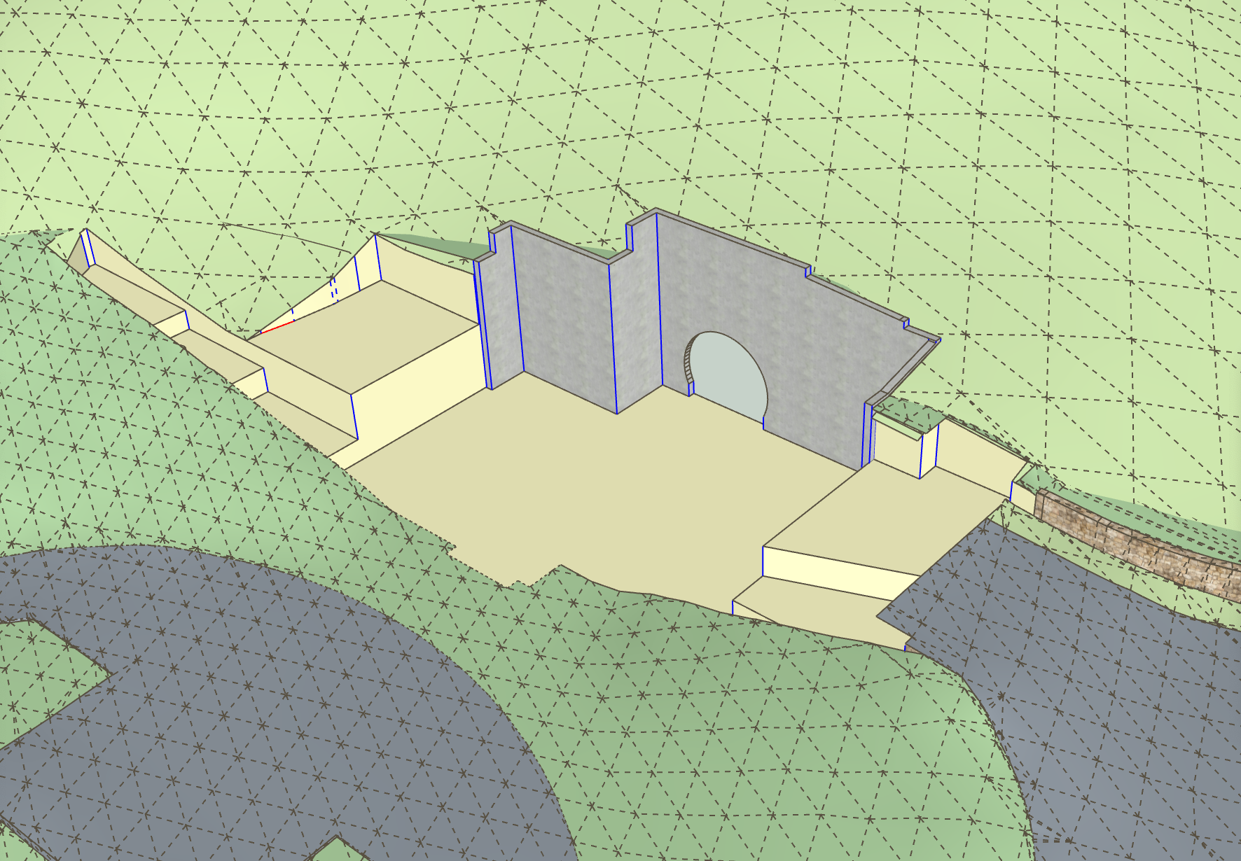
Having an accurate terrain is one thing. I can usually get that for my projects. Creating a neat and consistent grading and excavation model in an efficient manner is another. While modifying a building model throughout the design process can be straight forward (walls go in or out, roofs go up or down etc.), the intricacies of designing and modifying site models (terrain combined with hardscape, makes the task seem nebulous at times.
Hi, I design gardens so managing the terrain is one of the main things that I have to manage. The process that I have developed for measuring and modelling the site allows me to do it reasonably accurately. Creating the grades and calculating cut and fill is more complicated and sketchup could certainly do with some better tools for this but I don’t find it too complicated.
Always interested in ideas for site work. Here is a recent project. I did not necessarily have to show the building excavation ( the yellowish parts) but it helped in logically laying out the perimeter elevation (I think). Most of what I have to do is show a finished site model as well as use the model to work out design. you can probably tell the lighter green is the original terrain and I do always save an untouched version in the model so I can go back to if where needed. Don’t need cut and fill calcs. very often.