Good evening all. Our engineering company has been getting into 3D modeling for our civil site plans. I’m wondering if there’s a workflow that anyone knows about that we can read up on when taking something the size of a 1.5 miles x 1/4 mile site plan and bringing that into Sketchup.
We messed around with exporting a TIN surface that came in beautifully (after some tweaking on the CAD designers end with various triangle quantities, not my forte so forgive me lol) as well as separately exporting test corridors for the roads, curbs, etc and those looked good as well. He just isn’t sure on how he should be exporting the whole site plan (surface layer and corridors in one file) so I can start doing my thing in Sketchup/Lumion.
PS… we patched this detailed terrain into a 3d terrain of the surrounded area covering approx 12km x 12km
Also we had no CAD vector data for the site so I hand traced the PDF contour plan In Sketchup… then used Toposhaper to refine and elevate the contours…
No, trees were limited to the 1km x 1km area
I used different materials to define, forest, parkland, road verge, grass, ski slope and landscaped garden area then them asked TM to map trees / grass/ shrubs etc to those areas automatically. very quick… almost instant and renders, although not high realism only took maybe 30 seconds at 4k and then straight into powerpoint … it was for a feasibility study… only 4 weeks from start to finish. modelling was 90% rendering / presentation 10%
Looks awesome! I’ve been using TwinMotion and Lumion. TwinMotion does render so much faster than Lumion but, as you said, less realism. I have been looking into the Valiarchitects full suite but was all of what you did from scratch in SU or does it somehow incorporate Civil 3D exports?
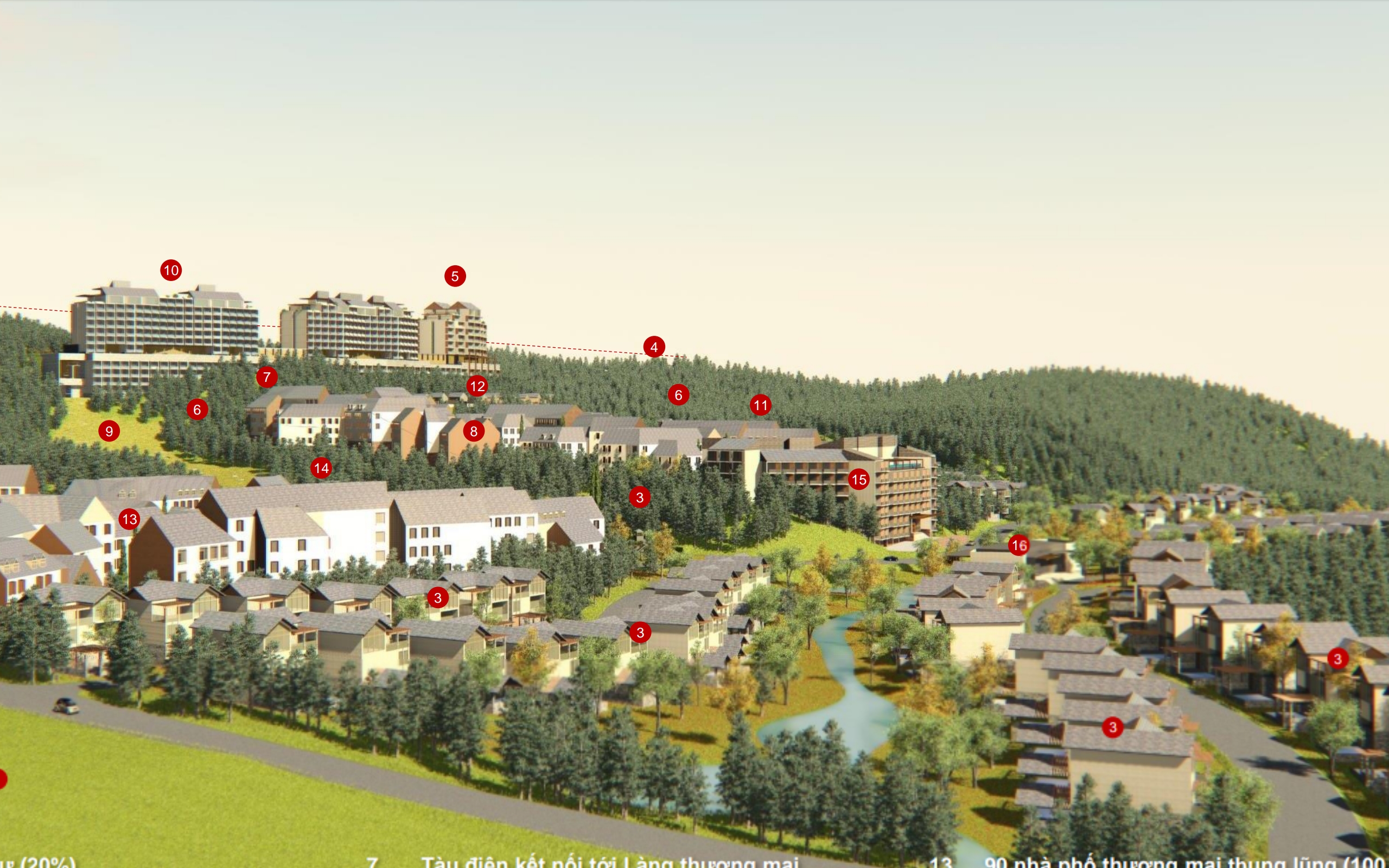
At this point, I’ve only taken the overall 2D site plan line work from C3D, filled the faces, and went from there. This project is going to include single family homes, paired cottages, apartments, hotels, retail-commercial plaza, and retail centers.
all done from scratch in SU… only had a dwg outline of the boundaries and PDF of a contour survey of the site.
So took a high res screen capture of the PDF,
imported and scaled it to the imported dwg in SU,
created a separate translucent ground plane in SU over the scan
traced the contours onto that plane [in top view ortho]
isolated the contour traces
used Fredo’s TopoShaper plugin to optimise, lift and form the terrain surface
Of course if you have a DWG contour plan you avoid having to scale and trace them… so much quicker
For the roads, a similar process
create a translucent plane over the site above your model and terrain…
draw your road centrelines on that plane in plan [ortho] view looking at your model below
use "Instant Road Nui " to project those centrelines onto the terrain as roads.
before doing this always backup your raw terrain model as a separate SU model
as is it easier to start on a fresh terrain if you edit the road positions.
PS, I also use Artisan for terrain refinement, smoothing, face subdivision, stitching edges together etc…
Very interesting. Apologies for the delay, too many projects, not enough time lol We purchased the whole Valiarchitect suite and I’ve been dabble around with it. Loving the stairs and windows/doors plugin!
We do have DWGs of the contours since our civil guys are creating the proposed site plan. Bringing that in made it easy to create the overall terrain with the built-in Sandbox tools. Having some issues with our road centerlines creating the paths in one process. Probably just some trial/error I’ll have to go through. Our roads will consist of road, curb, green space, and sidewalk. During the first few tries the results were a little wonky. Do you know if its possible to do cul-de-sacs with Vali?
I have not needed to model a cul-de-sac… check the Vali architect tutorials… they are fairly good… Also their terrain tool allows easy modelling of surfaces and building a cul-de-sac component and stitching the road to it should be relatively simple.
Oh, also you can use surfaces rather than centrelines to generate the road, so just setout your roads on a 2d surface using circles to define your cul-de-sacs and project down onto the topo with the roads plugin…
Could you be a little clearer in what you are asking. If you were a new user I would assume you wanted the download page, but since you have been here for more than 5 years it isn’t immediately clear what you are needing.
I think that you have a Pro subscription, and may still be using SketchUp 2021. If you are asking where to get SketchUp 2022 from, it would be this page:
I using current have Pro 2022 and Plus Design Build, 3kskeng. I looking civil engineering software design. I have experience on with software 1985-2022. I have worked in Singapore where I was responsible 120 engineers, architects for project building TBM and five station.
We have are a project which 57ha, 250 passive house SIPform prefabricated which will integrated with 934,370m2 PV estimate 26,829,264kW/hr and 28.8HW/hrs. Which includes bi-directional chargers to all houses.
We and team will construct shopping centre which will 12 Tesla Super Chargers.
We will submitted council which approved by end June 2022. The team will onsite by end June 2023. We the project finished end 2025.