Hi guys. I have a question and i have a feeling someone on this thread might has an answer. I scanned a building today and I had to do it in multiples files. I’m using an iPad pro 11" to scan and Trimble Scan Essential to put it in SketchUp. I read on the help page of TSE that multiples cloud can be load at once but they need to be aligned before the import. So, do you guys know how I can do that for free! I know Trimble Realworks would have done it but this is no where near my budget! Is there a little free software out there who could align my clouds? Does MeshLab or Blender can manage point cloud? Thx
Update: I think I might found my answer from another thread. It’s called: CloudCompare.
To be more in the subject of this thread, can undet load and align individually different clouds?
I use cloud compare and found it useful. Combining clouds into one space is straightforward but merging them (with any accuracy) is more difficult.
Recently I’ve started combining the clouds in the same space, aligning them with approximately the same axis and level but keeping them separate. Then I bring them into sketchup and build a model around one PC, make it a component then copy it to the next PC and model that bit and so on. It’s a bit of a workaround but it avoids importing and reimporting.
Other times I’ve joined clouds together as best as you can by eye and this is great for context models and site models.
If cloud compare allowed you to ‘nudge’ point clouds along different axes then that might solve the issues I’ve had but I haven’t found a way to do that yet.!
This is interesting, as you say the ability to ’nudge’ along different axis would help, the ability to nudge rotation would be useful as well, but the ability to select common points or planes from each scan is what’s really needed.
As an example of what the latest software can do - I did a 4 scan survey yesterday which would have been challenging a while ago because 3 of them were adjacent to each other at ground level with tons of overlap, but I needed a 4th to capture the top surface of a high wall, and the only way I could see that surface wa@s from the roof a nearby building, so I ended up with 4 scans, 1 of which had very little overlap with the other 3.
The scanners software managed to register all 4 scans into a single point cloud with ease, but unfortunately it only works with the manufacturers scanners . Basically, what it does is it lets you choose multiple points from each scan which are common in each, and then it somehow (miraculously) calculates the scanners position. Its uncanny how clever it is, and how accurate the results are, but maybe cloud compare has a similar feature you haven’t discovered yet?
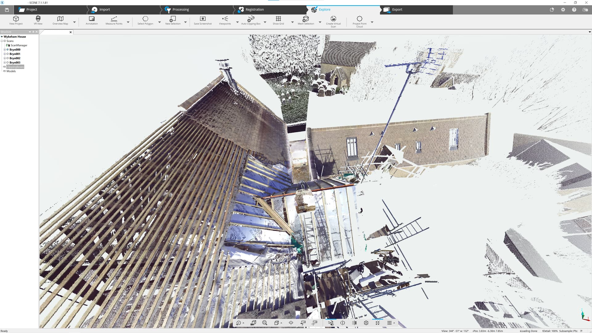
The photos below show how little overlap there was and the resulting point cloud in SketchUp.
Regarding Joe’s question: can Undet load and align individually different clouds? Undet can certainly load multiple clouds, you can toggle their visibility on and off, but its adjustable coordinates system are applied to all of the imported clouds, so no.
That’s a great scan. I think Joe and I are using Iphone/ Ipad scanning so it is not as high tech as what you have ( I dont think). What scanning software do you use - is it with the scanner?
By the way, you can individually rotate and move point clouds within Cloud Compare and there is also a mechanism to process multiple clouds and remove overlaps etc. However, I am not convinced that the scans I am doing on my iphone are accurate enough (at a detail level) to rely too heavily on the combined clouds.
One day I might invest in a scanner like yours - it would make things easier I think.
Yes the software which is called Faro - Scene, came with the scanner, and although it was hellish expensive, and I only use it about once a week, I have to say it has paid for itself over and over again. I am only down the road from you in Bristol so maybe if you have a project where you need a really accurate scan we could do a deal?
I’ve attached a couple of images from Scene showing yesterdays scan before exporting it for SketchUp and another of the scanner up on the roof. I don’t mind admitting I was preying for the pigeons to keep away as the scanner cost twice as much as my car
thank you all for your reply. I’ve been using CloudCompare today and it works really well for what I need. However, I was shocked when I realized that you can’t still load all the different segment clouds of one space in one Trimble Scan Essential Session. You can link them all so they all can be loaded individually on the same origin (axis), but what a bummer!!! Here’s what I read on the Help Center: Clouds
*If the RWP is created with the Realworks software, it can be divided into different segments. The Clouds settings area allows you to take advantage of this segmentation and visually turn on and off these individual segments as needed. Note: This functionality is only available for rwp files produced through Realworks software.
I found it so frustrating to see how scanning is SOOOOOO expensive! There’s a huge demand in my field (Stage & Event) for this feature but NO ONE is willing to pay me what I would have to charge if I would have to buy a proper scanner and some RIDICULOUSLY expensive software like Realworks.
Excuse me if I change slightly the subject of this post.
Have you considered paying a scanning company to do your scans? The scanning company will usually process the results into whichever point cloud format you require.
Alternatively have you you looked into hiring a scanner? The hire contract will usually include the use of a USB dongle which activates its own processing software?
When I started using digital surveys in 2015 I would employ a scanning company which cost around £800+ per project.
Then I started hiring the scanner and dongle for £250 per day and doing the scans myself which I did regularly for about 18 months before deciding to purchase.
You can combine the various clouds. Once you have brought them into cloud compare and positioned/ sorted them, click all of the tick boxes of the clouds you want to use and then go to File then Save As and give it a new name. This will combine them. This can then be brought into Sketchup as a single entity.
Thanks, YAMarchitects for your reply. What I meant was to bring them into SketchUp as multiple entities (just like layers) then you can turn them on/off in order to isolate certain elements. Now instead, I have to load PC one at a time. I did however create a few combined files.
By the way, I’m so sorry I shifted the subject of your initial post.
Turning on/off segments of a single e57 file is currently not available. A workaround is to select and import multiple e57 files (with the shift or ctrl key) when creating the scan essentials project. Each e57 will appear under the Cloud section in the Point Cloud Manager.
Thanks, kevin58, I’m reading your answer and it makes lots of sense. I’ve been using scan services multiple times, on big projects when the client has a decent budget. The problem I’m facing is more with this big demand of small budget. This is by far the majority of my call. As I calm down this morning (I wrote my post last night before bed) I realized that maybe all those customers will have to be filtered out into the ones who are actually ready to pay the real price.
The scan services in my area are much more expensive than yours. And the rental often only rent me material with a minimum of a few days which makes the bill in the multiple grand at least. This only works when I do multiple scans/clients in one rental. This is a rare situation.
This said, I agree with you and you make me REALLY rethink this part of my service offer. Thanks for your help.
Hello guys, I haven’t been able to follow forum news lately. I see you have a good discussion over here ;). I would like to intervene in this discussion and share UNDET news which will expand the use of point cloud data in SketchUp.
Recently we released a new version of Undet for SketchUp 2022. And one of the new features is UNDET Browser integration. Undet Browser is a free stand-alone point cloud viewer, created specifically to help you view, analyze and navigate your digital data as a panoramic view. Helping you to better and more quickly understand your scan data and share it with colleagues and customers.
Here is an overview video of UNDET Browser:
You will also have unique features when using the UNDET Browser in conjunction with the UNDET for SketchUp plugin. Below is a video with additional tools to streamline your point cloud workflow:
Really COOL! The browser refresh in SketchUp is pretty snappy. I can see some useful workflows viewing all this data in a seamless interface and superimposed within SketchUp.
Marius P and Undet are the clear winners here. It took weeks for Trimble to acknowledge that Scan Essentials does not properly display E57 point clouds from Matterport. And even now it is not clear that they have any intention of fixing it. Add the Undet Browser and the more flexible license options … Undet is the clear winner.
Hey, I decided to update the video in which we provide an overview of the features of Undet for SketchUp because some tools have been significantly improved since the last video in 2015 . This webinar, organized by us, will help you understand the possibilities and operation of Undet software for SketchUp pro. The webinar is free. More info → Undet Goes Live. Join us. Streamline your Point Cloud modeling workflow.
I know that the webinar broadcast time will not work for everyone. After the broadcast the next day, I will share the video recording




 . This webinar, organized by us, will help you understand the possibilities and operation of Undet software for SketchUp pro. The webinar is free. More info →

