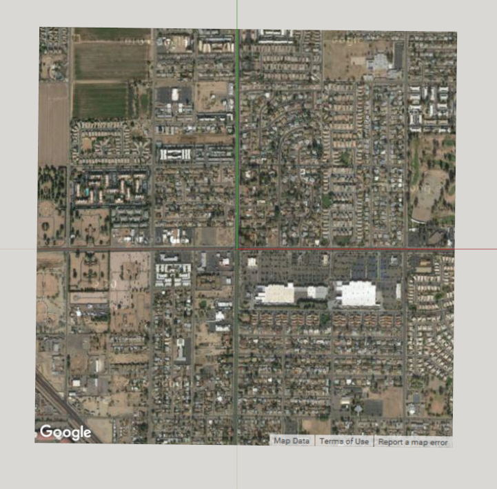
I used Google Earth to create a placemark in the center of an intersection where the roads are aligned almost exactly to true N/S and E/W. Using the coordinates of the placemark, I used the “Model Info >> Geo-location >> Set Manual Location…” followed by “Add More Imagery…” and got this as a result:
This ought to work, so it would seem there are details of what you are doing that aren’t coming across.
First of all, make sure you haven’t moved the drawing axes to be different from the model axes: right-click on an axis and select “reset”.
Next, move a reference point of your model to the axis origin.
Now geolocate the model manually to the known coordinates of that reference point.
Finally, rotate the model about the blue axis if necessary to get the correct orientation with respect to north, which should be along the green axis. Note: rotate the model, don’t rotate the drawing axes!
Steve, thank you! That worked perfectly! So, the old geolocation was where the drawing axes ended up when I reset them.
No wonder it was so difficult to find my model’s “reference point.”
I reset the axes.
I Edit>Select All
I dragged the entire model so the runway end point was at the axes intersection
I rotated the entire model so the runway was in the correct orientation to true north (green axis)
I manually set the location to the lat-long of the runway end via Window>Model Info>Geolocation>Set Manual Location
I previewed the model in Google Earth and… voila! It’s in the right place and the right orientation!
To double check, I entered a placemark in Google Earth and it was right at the end of the runway, where it should be!
Reset the Drawing Axes to their default position, aligned with the World Axes.
That done … Drawing Axes Origincoincides withWorld Axes Origincoincides withL,Lo coordinates of the model
By default, true north in SU Make is aligned with the +Y World Axis.
As mentioned earlier, moving the Drawing Axes does not move the inalterable World Axes system.
It follows that rotating the Drawing Axes will not alter true north.
Enable the Solar North Toolbar to be able to see the true north orange axis.
Click … View > Toolbars > Solar North
The Solar North extension is a Pro only feature that enables one to adjust the direction of true north in relation to the World Axes.
In SU Make one must simply accept true north is aligned with the +Y World Axes and rotate the model geometry such that it’s properly oriented to true north.
Now, for another issue. My model is “above” the green and red axes by about 20 feet. I think it got that way when I geolocated it the first time by importing the aerial photo from Google after having placed the model, approximately, on the aerial photo.
Being “above” the green and red axes causes the model to shadow whatever IS on the green and red axes.
How can I “snap” the model’s lower surfaces back to the surface defined by the green and red axes? I’ve tried the “move” tool but have been unsuccessful.
You can move all the model geometry a precise amount.
• Select all
• Then make the first click with the Move tool on any point you know should be on the ground plane.
• Move the geometry down a bit (any amount will do) and click again to complete the operation.
• Let go of the mouse and type [,0] and hit Enter
If, as you say, the runway geometry is perfectly flat, it might end up partially below sloped ground in GE.
You may need to move it up a bit in the model and export the .kmz file again.
Here’s more information on entering Absolute 3D Coordinates and Relative 3D Coordinates Moving Entities Around — SketchUp Help
When omitting the x and y values like this, [,0] SU uses the x, y values of the point picked to begin the move.
In GE:
Navigate to the perpendicular view you want.
Edit > Copy Image
Paste the clipboard into your favorite image editor … MS Paint will do … and save it.
Then, In SU:
Import the image as an image (not texture) into SU. Place and scale it accordingly
IMporting: yes. But you can open a second instance of SketchUp to geolocate that location.
Then you can select the terrain > Copy to clipbooard (in second SketchUp instance) > Paste from clipboard (in the first SketchUp instance).
You’ll have to unlock the terrain group before selecting it. Otherwise you can’t copy it.
Thanks, @Wo3Dan but I can’t geolocate the model using SU’s geolocation feature to superimpose the model on the terrain, as the terrain is nondescript. I’ve had to geolocate my model by lat-long manually entered. It’s fine to then preview it in Google Earth, but I can’t get the terrain back into SU. I CAN get a photo of the terrain back into SU.
I have a 3D model that has georeference information. I have just installed the plugin, and it’s work.
The question is: Is there a way to set a camera by latitude and longitudine to respect 2D point?